


Latest Version
Version
1.0.0
1.0.0
Update
June 17, 2025
June 17, 2025
Developer
LEAN ASIA
LEAN ASIA
Categories
Design
Design
Platforms
Android
Android
Downloads
0
0
License
Free
Free
Package Name
com.lean.gpscamera
com.lean.gpscamera
Report
Report a Problem
Report a Problem
More About GPS Map Camera
GPS Map Camera is the ultimate tool to automatically add GPS location, time, date, map, and even weather information to your camera photos. Whether you're traveling, surveying, working on-site, or documenting reports, this app provides an easy, accurate, and professional way to capture visual evidence with real-world context.
📸 KEY FEATURES:
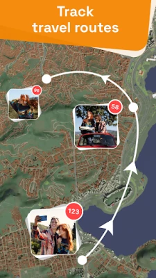
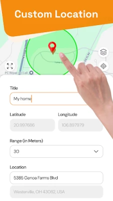
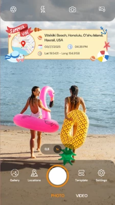
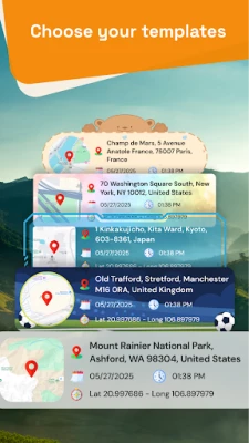
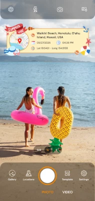
📍 Location & Map Overlay
• Automatically add current GPS coordinates (latitude, longitude, altitude)
• Display street name, city, state, country, postal code, etc.
• Embed live map view (Standard, Satellite, Terrain) on top or bottom of the photo
• Show compass direction and accuracy info (optional)
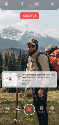
🕒 Timestamp & Date Stamp
• Add date and time in customizable formats (YYYY-MM-DD, 24h/12h, etc.)
• Auto-sync time zone and adjust format based on your region
• Customize font style, size, color, and placement
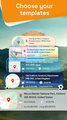
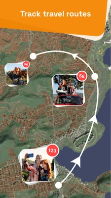
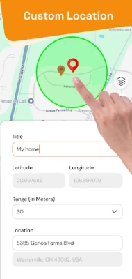
🗂️ Organize by Location
• Automatically group captured photos and videos by GPS location
• Easily browse media sorted by city, area, or specific coordinates
• View and manage files based on site visits, inspection zones, or travel points
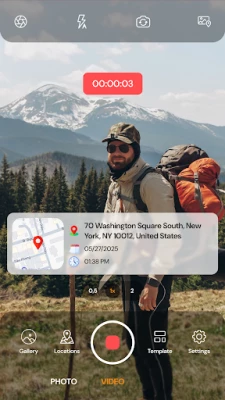
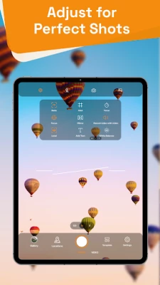
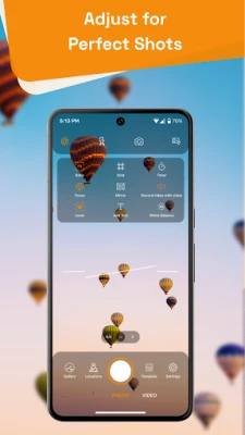
🎥 Advanced Photo & Video Capture
• Capture both photos and high-quality videos with GPS, date, and map overlay
• Add stamps and info in real-time while recording video
• Switch between front and back camera seamlessly during shooting
• Pin map location to media files for accurate geo-verification
• Customize overlays with dynamic elements like zoom level, location accuracy, or time duration
📷 Camera & Storage
• Built-in camera with preview and adjustable resolution
• Option to use native/default camera and apply stamps post-capture
• Auto-save to folder, gallery, or SD card
• Quick share via email, WhatsApp, Telegram, Google Drive, and more
📶 Works Offline
• Capture with last known GPS coordinates when offline or no signal
• Manual location tagging available
🔐 Privacy & Security
• All data stays on your device unless you choose to share
• No unnecessary background data collection
• GDPR & privacy-compliant
---
🧰 IDEAL FOR:
• Fieldwork inspections and engineering reports
• Construction, infrastructure, and real estate documentation
• Delivery, logistics, and fleet tracking
• Surveying, agriculture, maintenance, and facility audits
• Travel photography with real-time geo-tagging
• Law enforcement, site evidence, or incident capture
• Professional or personal use where geo-verification is needed
Whether you're a civil engineer, site inspector, delivery driver, traveler, or just someone who wants to document where a photo was taken, GPS Map Camera is your reliable camera tool.
---
🎯 WHY CHOOSE GPS MAP CAMERA?
• Save time by eliminating manual data entry
• Generate photos that are useful for reports, claims, records, and presentations
• Enhance accountability and transparency in operations
• Stand out with professional-quality image stamps
---
💡 TIPS FOR BEST USE:
• Enable location permission for accurate tagging
• Allow weather access to fetch real-time data
• Calibrate compass for correct orientation
• Use templates to match your reporting or branding style
• Turn on auto-save for fast workflows
---
🆓 FREE & PREMIUM:
Try all essential features completely FREE. Upgrade to Pro for:
• Custom templates and batch stamping
• Remove ads
• High-res stamp quality
• Priority support and future updates
---
Download GPS Map Camera today and start capturing smarter, more informative photos with automatic stamps that bring context to every image. Ideal for work, travel, or everyday life – GPS Map Camera turns your phone into a smart geo-tagging camera tool.
📍 Location & Map Overlay
• Automatically add current GPS coordinates (latitude, longitude, altitude)
• Display street name, city, state, country, postal code, etc.
• Embed live map view (Standard, Satellite, Terrain) on top or bottom of the photo
• Show compass direction and accuracy info (optional)
🕒 Timestamp & Date Stamp
• Add date and time in customizable formats (YYYY-MM-DD, 24h/12h, etc.)
• Auto-sync time zone and adjust format based on your region
• Customize font style, size, color, and placement
🗂️ Organize by Location
• Automatically group captured photos and videos by GPS location
• Easily browse media sorted by city, area, or specific coordinates
• View and manage files based on site visits, inspection zones, or travel points
🎥 Advanced Photo & Video Capture
• Capture both photos and high-quality videos with GPS, date, and map overlay
• Add stamps and info in real-time while recording video
• Switch between front and back camera seamlessly during shooting
• Pin map location to media files for accurate geo-verification
• Customize overlays with dynamic elements like zoom level, location accuracy, or time duration
📷 Camera & Storage
• Built-in camera with preview and adjustable resolution
• Option to use native/default camera and apply stamps post-capture
• Auto-save to folder, gallery, or SD card
• Quick share via email, WhatsApp, Telegram, Google Drive, and more
📶 Works Offline
• Capture with last known GPS coordinates when offline or no signal
• Manual location tagging available
🔐 Privacy & Security
• All data stays on your device unless you choose to share
• No unnecessary background data collection
• GDPR & privacy-compliant
---
🧰 IDEAL FOR:
• Fieldwork inspections and engineering reports
• Construction, infrastructure, and real estate documentation
• Delivery, logistics, and fleet tracking
• Surveying, agriculture, maintenance, and facility audits
• Travel photography with real-time geo-tagging
• Law enforcement, site evidence, or incident capture
• Professional or personal use where geo-verification is needed
Whether you're a civil engineer, site inspector, delivery driver, traveler, or just someone who wants to document where a photo was taken, GPS Map Camera is your reliable camera tool.
---
🎯 WHY CHOOSE GPS MAP CAMERA?
• Save time by eliminating manual data entry
• Generate photos that are useful for reports, claims, records, and presentations
• Enhance accountability and transparency in operations
• Stand out with professional-quality image stamps
---
💡 TIPS FOR BEST USE:
• Enable location permission for accurate tagging
• Allow weather access to fetch real-time data
• Calibrate compass for correct orientation
• Use templates to match your reporting or branding style
• Turn on auto-save for fast workflows
---
🆓 FREE & PREMIUM:
Try all essential features completely FREE. Upgrade to Pro for:
• Custom templates and batch stamping
• Remove ads
• High-res stamp quality
• Priority support and future updates
---
Download GPS Map Camera today and start capturing smarter, more informative photos with automatic stamps that bring context to every image. Ideal for work, travel, or everyday life – GPS Map Camera turns your phone into a smart geo-tagging camera tool.
Rate the App
Add Comment & Review
User Reviews
Based on 0 reviews
No reviews added yet.
Comments will not be approved to be posted if they are SPAM, abusive, off-topic, use profanity, contain a personal attack, or promote hate of any kind.


More »

Popular Apps

Peacock TV: Stream TV & MoviesPeacock TV LLC

Mr.Billion: Idle Rich TycoonIDSIGames

Ludo King®Gametion

WPS Office-PDF,Word,Sheet,PPTWPS SOFTWARE PTE. LTD.

TCG Card Store Simulator 3DBlingames

Statastic Basketball TrackerStatastic Solutions FlexCo

FatsomaFatsoma Android

3D Chess GameA Trillion Games Ltd

Truth or Dare Game - OweeOwee

RealVNC Viewer: Remote DesktopRealVNC Limited
More »
Editor's Choice

Grim Soul: Dark Survival RPGBrickworks Games Ltd

Craft of Survival - Gladiators101XP LIMITED

Last Shelter: SurvivalLong Tech Network Limited

Dawn of Zombies: Survival GameRoyal Ark

Merge Survival : WastelandStickyHands Inc.

AoD Vikings: Valhalla GameRoboBot Studio

Viking Clan: RagnarokKano Games

Vikings: War of ClansPlarium LLC

Asphalt 9: LegendsGameloft SE

Modern Tanks: War Tank GamesXDEVS LTD